[COM] M2 Northern Connector | 15.5km | $867m

Threads relating to transport, water, etc. within the CBD and Metropolitan area.
Message
Author
User avatar
ChillyPhilly
Super Size Scraper Poster!
Posts: 2764
Joined: Sun Dec 07, 2008 11:35 pm
Location: Kaurna Land.
Contact:

[COM] Re: Northern Connector | 14km | $1b

#541 Post by ChillyPhilly » Mon Feb 20, 2017 2:03 pm

Works continue around the Motorway/PRExy interchange. Both east and west of this interchange, a chunk of the median has been removed. More and more land is gradually being cleared to the north.

Here's a refresher:

Image
Our state, our city, our future.

All views expressed on this forum are my own.

SBD
Super Size Scraper Poster!
Posts: 2723
Joined: Thu Apr 03, 2014 3:49 pm
Location: Blakeview

[COM] Re: Northern Connector | 14km | $1b

#542 Post by SBD » Mon Feb 20, 2017 2:53 pm

Is that the current design? It shows the railway in the diagram, and has the south-to-west ramp different than other drawings I have seen that have it entering Salisbury Highway east of the current bridge.

Has anyone seen or heard "the plan" for how the bikeway/shared paths will cross Port Wakefield Road and Salisbury Highway? Are there bridges/underpasses/overpasses or will there just be "watch for bikes/pedestrians signs on the highways?

User avatar
Norman
Donating Member
Donating Member
Posts: 6485
Joined: Sun Mar 25, 2007 1:06 pm

[COM] Re: Northern Connector | 14km | $1b

#543 Post by Norman » Mon Feb 20, 2017 4:08 pm

I suspect there might still be a "detailed design" document to come with final details. Let's hope so anyway.

rev
SA MVP (Most Valued Poster 4000+)
Posts: 6424
Joined: Sat Nov 11, 2006 12:14 pm

[COM] Re: Northern Connector | 14km | $1b

#544 Post by rev » Mon Feb 20, 2017 5:51 pm

SBD wrote:Is that the current design? It shows the railway in the diagram, and has the south-to-west ramp different than other drawings I have seen that have it entering Salisbury Highway east of the current bridge.

Has anyone seen or heard "the plan" for how the bikeway/shared paths will cross Port Wakefield Road and Salisbury Highway? Are there bridges/underpasses/overpasses or will there just be "watch for bikes/pedestrians signs on the highways?
Cyclists and pedestrians aren't allowed to be on freeways & motorways.
Haven't you noticed the signs at the start of such roads that say they are prohibited to be on there?
User avatar
Splashmo
High Rise Poster!
Posts: 373
Joined: Tue Oct 09, 2007 5:14 pm
Location: Adelaide

[COM] Re: Northern Connector | 14km | $1b

#545 Post by Splashmo » Mon Feb 20, 2017 7:59 pm

rev wrote:Cyclists and pedestrians aren't allowed to be on freeways & motorways.
Haven't you noticed the signs at the start of such roads that say they are prohibited to be on there?
There's a separate path next to the Northern Expressway and there's a new 16km path proposed for the Connector. I imagine SBD is asking how they'll be connected.

rev
SA MVP (Most Valued Poster 4000+)
Posts: 6424
Joined: Sat Nov 11, 2006 12:14 pm

[COM] Re: Northern Connector | 14km | $1b

#546 Post by rev » Tue Feb 21, 2017 3:24 pm

Splashmo wrote:
rev wrote:Cyclists and pedestrians aren't allowed to be on freeways & motorways.
Haven't you noticed the signs at the start of such roads that say they are prohibited to be on there?
There's a separate path next to the Northern Expressway and there's a new 16km path proposed for the Connector. I imagine SBD is asking how they'll be connected.
Yes you're right I forgot about the paths.

User avatar
drsmith
Legendary Member!
Posts: 513
Joined: Wed Nov 07, 2007 3:35 pm
Location: Perth

[COM] Re: Northern Connector | 14km | $1b

#547 Post by drsmith » Tue Feb 21, 2017 3:46 pm

SBD wrote:Is that the current design?
No.

A later render shows South Road northbound to Salisbury Highway eastbound passing over both Northern Connector carriageways.
Attachments
14828d54c7c4ca53dd03736011e35528.jpg
14828d54c7c4ca53dd03736011e35528.jpg (57.76 KiB) Viewed 4013 times

User avatar
drsmith
Legendary Member!
Posts: 513
Joined: Wed Nov 07, 2007 3:35 pm
Location: Perth

[COM] Re: Northern Connector | 14km | $1b

#548 Post by drsmith » Tue Feb 21, 2017 3:58 pm

The image above is the same as in a Powerpoint presentation from August last year on Lend Lease's Northern Connector project site.

https://gateway.icn.org.au/project/3748 ... 1468345768

Another change from earlier designs is the all movement access interchange at Bolivar. While the Globe Derby interchange and connection to PWR is shown, it's not indicated as part of the current build. Shared use paths are also shown.

SBD
Super Size Scraper Poster!
Posts: 2723
Joined: Thu Apr 03, 2014 3:49 pm
Location: Blakeview

[COM] Re: Northern Connector | 14km | $1b

#549 Post by SBD » Wed Feb 22, 2017 12:19 am

Splashmo wrote:
rev wrote:Cyclists and pedestrians aren't allowed to be on freeways & motorways.
Haven't you noticed the signs at the start of such roads that say they are prohibited to be on there?
There's a separate path next to the Northern Expressway and there's a new 16km path proposed for the Connector. I imagine SBD is asking how they'll be connected.
Yes, I was asking about the connection from the current Stuart O'Grady Bikeway which ends on the east side of Port Wakefield Road to the new path along the Northern Connector, and between the southern end of the new path to both the westbound shoulder of Salisbury Highway/Port River Expressway and the paths at ground level under the South Road Superway. Both crossings are drawn on most planning maps with straight lines across the roads, but I have not seen any indication of whether there will be bridges, underpasses, or just "bikes crossing" and "watch for pedestrians" signs. Different versions of the drawings have slight variations on where these lines are drawn, so somebody must be thinking about it, but I have not seen anything authoritative. The closest I saw was the version that showed the Stuart O'Grady Bikeway extended parallel to PWR to Heaslip Road, then cross with the traffic lights there, but that has gone from the latest drawings and returned to a straight crossing at the south side of the northern interchange.

Cyclists and pedestrians are not permitted on the Northern Expressway or the elevated South Road Superway, but cyclists are permitted on Port Wakefield Road, Salisbury Highway and Port River Expressway. The current interchange supports cyclists joining the bridge at the end of the northbound carriageway, so they cross the Port River Expressway on the shoulder of the same bridge that carries cars, trucks and road trains if they are coming from Wingfield or Regency Park and heading towards Mawson Lakes and Salisbury or up Port Wakefield Road.

The current Stuart O'Grady Bikeway is seen as a safe place for younger or inexperienced riders to practice riding longer distances with only a few road crossings. The new path will also have connections to the Little Para River and Dry Creek trails, so I expect there will be more people interested in using it to find safe routes between the Salisbury/Mawson Lakes/Paralowie areas and the Wingfield/Port Adelaide/Semaphore areas.

User avatar
ChillyPhilly
Super Size Scraper Poster!
Posts: 2764
Joined: Sun Dec 07, 2008 11:35 pm
Location: Kaurna Land.
Contact:

[COM] Re: Northern Connector | 14km | $1b

#550 Post by ChillyPhilly » Sat Mar 04, 2017 4:40 pm

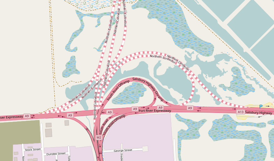
This is OpenStreetMap's layout:

Image
Our state, our city, our future.

All views expressed on this forum are my own.

Westside
High Rise Poster!
Posts: 252
Joined: Tue May 12, 2009 4:30 pm

[COM] Re: Northern Connector | 14km | $1b

#551 Post by Westside » Mon Mar 06, 2017 12:39 pm

ChillyPhilly wrote:This is OpenStreetMap's layout:
The top-right corner of the image aptly indicates the grains of salt with which OpenStreetMaps should be read.

User avatar
monotonehell
VIP Member
VIP Member
Posts: 5466
Joined: Fri Feb 01, 2008 12:10 am
Location: Adelaide, East End.
Contact:

[COM] Re: Northern Connector | 14km | $1b

#552 Post by monotonehell » Mon Mar 06, 2017 12:43 pm

Westside wrote:
ChillyPhilly wrote:This is OpenStreetMap's layout:
The top-right corner of the image aptly indicates the grains of salt with which OpenStreetMaps should be read.
:applause:
Exit on the right in the direction of travel.

User avatar
ChillyPhilly
Super Size Scraper Poster!
Posts: 2764
Joined: Sun Dec 07, 2008 11:35 pm
Location: Kaurna Land.
Contact:

[COM] Re: Northern Connector | 14km | $1b

#553 Post by ChillyPhilly » Mon Mar 06, 2017 3:41 pm

Westside wrote:
ChillyPhilly wrote:This is OpenStreetMap's layout:
The top-right corner of the image aptly indicates the grains of salt with which OpenStreetMaps should be read.
Good call. Image
Our state, our city, our future.

All views expressed on this forum are my own.

rev
SA MVP (Most Valued Poster 4000+)
Posts: 6424
Joined: Sat Nov 11, 2006 12:14 pm

[COM] Re: Northern Connector | 14km | $1b

#554 Post by rev » Wed Mar 08, 2017 8:37 pm

Not sure if anyone's posted this already but at the northern end of the superway, where the NC will run, work is well underway.

User avatar
ChillyPhilly
Super Size Scraper Poster!
Posts: 2764
Joined: Sun Dec 07, 2008 11:35 pm
Location: Kaurna Land.
Contact:

[COM] Re: Northern Connector | 14km | $1b

#555 Post by ChillyPhilly » Wed Mar 08, 2017 11:00 pm

rev wrote:Not sure if anyone's posted this already but at the northern end of the superway, where the NC will run, work is well underway.
I've been trying to figure out what exactly they're doing with the PRExy median. In two spots, it's been removed and replaced with bitumen. A future u-turn spot for when they demolish the existing interchange, perhaps? This makes sense with the westernmost clearing, between South Road and Hanson Road, but the eastern median clearing doesn't fit this theory.
Our state, our city, our future.

All views expressed on this forum are my own.

Post Reply

Who is online

Users browsing this forum: No registered users and 0 guests